Open the location a photo was taken on Google Maps with these Windows tools
Sometimes, when you look at a particularly great photo, you may wonder where it was taken. While an image of the la tour Eiffel, the Golden Gate Bridge, or the Kremlin reveals right away where it was taken, the same cannot be said for locations that are less engraved in our minds.
If the photographer does not reveal where the photo was taken, you have little options to find that out on your own. While you could do a reverse image search and hopefully find matching photos that reveal more, it is often the case that the effort is fruitless.
So-called EXIF data or metadata may provide additional clues, provided that the information has been saved in the first place and not been deleted by the photographer or editor of the photo before it was published. Tools like Exif Pilot Editor or ExifTool provide editing options.
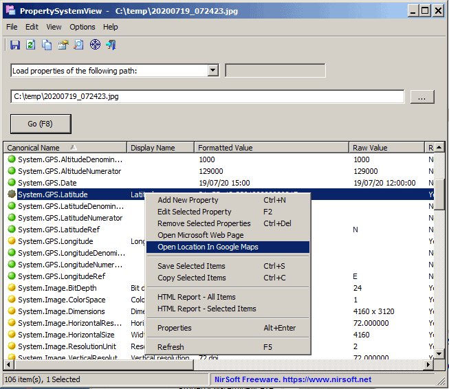
Nirsoft updated two Windows tools this week that introduce a useful option to look up the photo's location on Google Maps. The feature works only for .jpg images and only if GPS information is available as metadata. While that limits the usefulness somewhat, as many photos may not be provided as JPG images or may not contain the necessary GPS information, it is better than not having such an option at all.

All you have to do to use the new feature is the following:
- Download either one of the following tools: PropertySystemView or ExifDataView. Both programs are free and portable. The core difference between the two programs is that ExifDataView may only read metadata of JPG images while PropertySystemView metadata of other files, e.g. Office documents, as well. ExifDataView is compatible up to Windows 8.1, PropertySystemView supports all supported versions of Windows and some unsupported ones (notably Windows 7).
- Extract the downloaded archive and run the application on the system.
- Open a jpg photo in the application that you just ran.
- Right-click in the main window of the program after the photo has been loaded and select "Open location in Google Maps".
- The program opens the location using Google Maps in the default web browser of the system.
Closing Words
While it is possible to check the information manually to open the location on Google Maps, it is usually quicker to use one of the two Nirsoft programs for that.
Now You: do you use Nirsoft tools? If so, which?








I use WSCC which is portable software that integrates all Sysinternals and Nirsoft tools into a searchable application, and manages updates of all the tools etc. Over 300 utilities all up!
I’ve assembled a nice collection of photographic wallpapers over the years and am curious to know where some of them were taken. Unfortunately, when I saved them, I didn’t rename them with descriptive names (when accurate descriptions were even provided). Also unfortunately, EXIF geotags seem to be absent from *all* of the ones I’ve tried checking so far. ( “Open Location in Google Maps” was grayed out in PropertiesSystemView and there was no EXIF data at all in the file Properties “Details” tab.)
Doing reverse image searches from a browser is kind of a pain, so I dug around a little and found a Windows Explorer / File Explorer shell extension called “GoogleImageShell” on GitHub. It’s billed as being for Windows 7 and up. It’s been archived, but it worked for me in Windows 10 1909 and I’ve already used it to find a detailed description and city-level location for one of my wallpapers. Nice!
(I right-clicked on the GoogleImageShell.exe installer and ran it “as Administrator” to subsequently install it for all users. Now *anyone* on the computer can go through a pictures folder in File Explorer, right-click on a file, and choose “Search on Google Images” for any unidentified image they’re curious about.)
The source code is of course provided, so I suppose an enterprising coder could adapt it to Bing Image Search.
Anyway, I’m grateful to this article for giving me the kick in the pants I needed to find GoogleImageShell because — let’s be honest — I was *never* going to research my wallpapers from a *browser*. From File Explorer? *Much* more likely. ;-)
As for Nirsoft Utilities generally, I maintain a complete collection and I use some of them from time to time. (Ditto for Sysinternals Suite.) They can be super useful, but the downside is that some antivirus programs still flag a fair number of them as “potentially unwanted programs,” meaning you have to set up exclusions for them. (I don’t specifically remember having this problem with Windows Defender, though I couldn’t swear to it, but Sophos seems to think Nirsoft tools are the *spawn of Satan*, and I’ve run into the problem with other antivirus programs as well.)
@Peterc: As for Nirsoft Utilities generally, I maintain a complete collection and I use some of them from time to time. (Ditto for Sysinternals Suite.) They can be super useful, but the downside is that some antivirus programs still flag a fair number of them as “potentially unwanted programs,†meaning you have to set up exclusions for them.
Nirsoft’s official view on the matter:
https://www.nirsoft.net/about_nirsoft_freeware.html
“False Positive” Issues
As my Web site became more popular, a very annoying problem started to appear frequently: “False Positive” alerts in AntiVirus software.
This means that AntiVirus/AntiSpyware programs detect my utilities as infected with Virus/Trojan/Spyware while my utilities are clean from any malicious code.
Each time that a popular AntiVirus software begins to detect one of my utilities as Virus or Trojan,
my email is flooded with messages from worried people that think my Web site is infected with Viruses.
Some of them even blame me that I spread Viruses through my Web site.
But the truth is that I have never had any Virus/Trojan/Spyware in my tools.
All the alerts and warnings displayed by the AntiVirus programs regarding my utilities are simply wrong, and cause a widespread panic without a reason.
Due to the large amount of “False Positive” alerts, I created a special Web page that displays
the major “False Positive” problems with NirSoft utilities: False Positive Reports
https://www.nirsoft.net/false_positive_report.html
This Web page is also message to all Antivirus companies that they must improve the quality and the reliability of their Virus detection mechanism.
> Now You: do you use Nirsoft tools? If so, which?
https://i.imgur.com/BStfEFk.png
※ Excluding the “appropriate language.zip file” in the screenshot, all 32 items are used.
The special advantage of the “Nirsoft” application software are:
There are very compact (program size) and operates lightly because it has a simple design that are specialized for the purpose of use.
All of them are available in a “Portable” specification, so don’t have to worry about polluting the registry, and simply “Delete the program’s folder” to remove the app.
Due to the developer’s outstanding competence, all of their products are excellent and eliminate the need for other third-party apps.
I strongly recommend that try the “Nirsoft” apps first, without being interested in the unfamiliar products.
Nirsoft Main Page
https://www.nirsoft.net/
NirBlog, The official blog of nirsoft.net
https://blog.nirsoft.net/
Nirsoft, Frequently Asked Questions
https://www.nirsoft.net/faq.html
Articles, Tips and Tricks, and more…
https://www.nirsoft.net/articles/
Anyone know of a program that will take a bunch of JPG’s with GPS coordinates and place them on a google map and save as HTM to place on a web site?
The following will work; there may be a way with EXIF data. The video that follows may prove useful as well.
https://www.youtube.com/watch?v=NtgFqTpwDs8
Google Photos should provide a URL link; or make a dummy Google or Blogger site.
https://www.google.com/maps/about/mymaps/
Bing Maps
http://www.intellspot.com/open-source-mapping-software/
https://www.openstreetmap.org/#map=4/35.28/-90.53
Includes GPS Traces?
Maybe–sounds like a hit and miss:
No EXIF data was found in the files. Geolocation with Google Maps requires unaltered photo files in order to process the data. Social networking sites like Facebook and Twitter strip out EXIF data from uploaded photos.
A DSLR or compact camera with a built-in GPS or external GPS unit is required to automatically geotag your photos while you are shooting. If you are using a smartphone (Android, iPhone, etc.) to take your photos, location and geotagging services should be enabled.
I use so many Nirsoft tools from time to time that I’d spend hours listing them:
https://www.nirsoft.net/
wifiinfoview
taskschedulerview
previousfilesrecovery
chromecacheview
This one would make things easier provided location info is there. One has to wonder what’s going on upstairs if an individual has no idea where their photos were taken.
Hmmmm . . . super tool for law enforcement–especially with smartphones.
Small typo:
“PropertySystemView supports all support versionsâ€
Should be: “…supports all versionsâ€