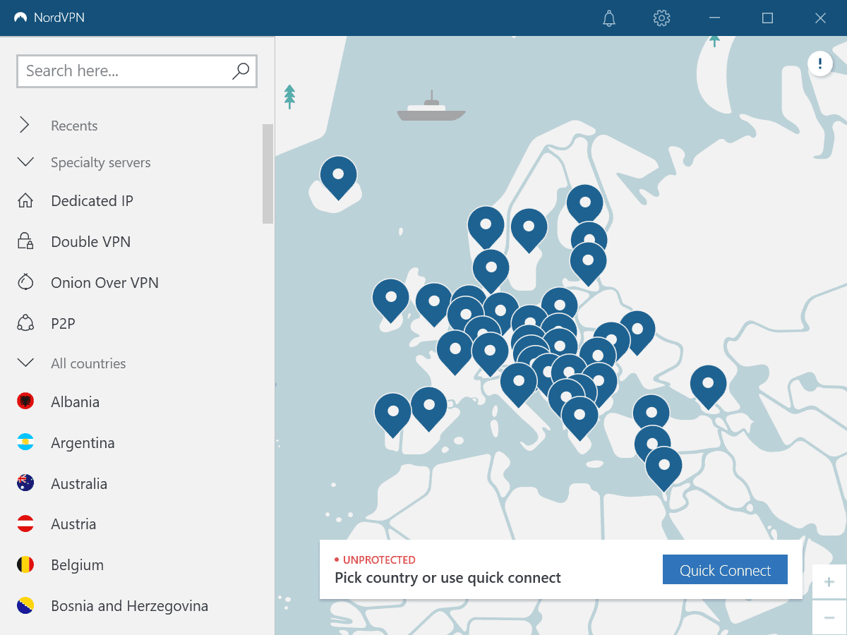
Qwant Maps: open source Google Maps alternative launches

Qwant, the French search engine that respects users privacy, has launched a beta version of Qwant Maps, a, you guessed it, privacy respecting mapping service.
Qwant Maps is an open source project that anyone may contribute to. The data is hosted on GitHub and developers may run their own version by following the instructions on the project website.
The beta version of the mapping service supports desktop and mobile access, and it works similarly to how other mapping services such as Google Maps, Bing Maps, or OpenStreetMap work.
Qwant Maps displays a search field at the top to find points of interests quickly; just type in an address or the name of a place to jump to it right away. Descriptions are provided for places that you activate on the map; these are taken from Wikipedia and maybe also other sources.
The services module displays a handful of options. Click on one of the presets, e.g. hotel, pharmacy, or supermarket, to display a list of available locations on the active map.
Places can be added to the favorites without signing in; in fact, I could not find an option to sign in to Qwant Maps anywhere on the site.
Directions are supported as well. Just click on directions to get started and add start and end points. You may pick them from the favorites or using the keyboard to input them manually.
Additional options, e.g. to avoid certain types of streets, or to add additional stops, are not provided as well.
Driving, walking, and cycling directions are provided at the time. The service lacks transit and flight information that Google Maps supports; there is also no option to get navigational instructions while on the move.
Users may manipulate the URL of Qwant Maps directly to jump to certain locations or use certain functionality:
- Search for a location: https://www.qwant.com/maps/#map=<zoom level>/<latitude>/<longitude>
- Search for a specific place: https://www.qwant.com/maps/place/<id>
- Routing requests: https://www.qwant.com/maps/routes/?origin=latlon:48.8459543:2.3714015@LExpress_de_Lyon&destination=latlon:48.8702200:2.2786330&arrival_datetime=20160613T135400&mode[]=walking#map=18.00/48.8459543/2.3714015
Qwant Maps' main appeal is privacy at the time as it sets the service apart from Google Maps, Bing Maps, and many other mapping services.
Our commitments for the protection of your privacy and your personal data are available here and apply to the QWANT MAPS service. When you request to enable geolocation on QWANT MAPS, your browser or application will return to Qwant a location that Qwant does not maintain.
It is used temporarily to specify your query and thus center the map displayed, and indicate the geographical point corresponding to the position returned. However, we encourage you to disable geolocation whenever it is no longer needed.
Closing Words
Qwant Maps is a beta service and it shows when it comes to functionality. While you get the core features out of the service right now, you will notice here and there that some features are missing. The focus on privacy could convince some users to switch to it or use it as well.
Now You: which mapping service do you use?


Maps are, “accuracy” is more important than anything.
In addition to the city, village, railway, roads, rivers, etc. scale drawings, public facilities and major buildings (stores, etc) will be covered, and accuracy that can be used as car navigation will be necessary.
It seems that the choices from Google Map (Google Earth), Bing Maps, and (Apple)Maps are realistic.
Marble is an unstable behavior. Selecting a target and zooming will cause loops and freezes.
Qwant Maps is extremely inaccurate and not practical.
As a specific example
(Quote: Yuliya said on June 29, 2019 at 2:35 pm)imgur.com/Oo40uvK
Privacy management is important, but inaccurate information does not help.
By the way, although it does not cover the whole world, “Zenrin” stands out for its accuracy and precision.
https://en.wikipedia.org/wiki/Zenrin
About Zenrin
Our mission is to be a leader in global mapping, providing premium map services and products.
Meh, they should just use Apple Maps, like DuckDuckGo does.
But then again, I wouldn’t be using Qwant, DDG, or Startpage for their mapping services, lol
I just use Maps.app for map-related purposes and Qwant/DDG/Startpage for searching.
Beta is being generous for this thing. I’m not sure it knows where the UK is
But I can understand the SketchyBoys of Ghacks wanting this since all the Western govts are zeroing on you as I type, and GCHQ is coming down your street atm
(stop hacking and you dont need to worry so much ffs)
This is not even Alpha. More like an initial sketch in a developer’s notepad.
To run google maps smoothly in your browser you need: i9 /128Gb ram / GTX 1080 overclocked to GTX 900000000 ultra+ watercooled with liquid nitrogen. And, of course a 100Mbps fiber connection.
If you don’t have that kind of hardware you’ll have a slow experience.
openstreetmap.org doesn’t have that many features but is way lighter to run and doesn’t track you like google.
Or you could use Bing Maps/HERE Maps for a more full-featured alternative to GM.
It didn’t jump to Amsterdam when I typed that in. Instead a dropdown menu was displayed with “Amsterdam North Holland” as an option. However, loading that just results in the background staying the same. I even tried loading the other locations but that didn’t work either.
At its current version this is pretty rubbish for UK addresses.
The administrative regions in my country aren’t even displayed if I zoom in too much. This thing has a long way to go.
Great news !!!
Well I use either Apple Maps or Google and isn’t the whole ideal of maps is to know where you are and a little bit about you? Yeah I get that these services track you and for me it’s a added function that I am ok with, that provides added benefits.
Nah, offline functionality is where it’s at, who cares about geolocation, if you pay attention, and check the map regularly. Hell, with ~30 Gigs storage you can have the entire world maps on your device.
Yeah. Traffic info is nice, otherwise I don’t need to see an image of me moving on a map. The map service needs to know absolutely nothing about me to show a map.
Distance and area calculations are handy, too.
The strong point of Google maps and Waze is not the map but the navigation that takes into account real-time traffic conditions gathered from other users on the roads.
Lol, “real time”. More like real time ads. Twice already in as many months did Waze and Gmaps forget there’s a closed road. Was closed by police for hours before I arrived. Instead of a detour advised by the radio station, a 30 min drive turned into 4 hours. Four hours.
Needless to say this was in the busiest part of the country in one of Waze’s most popular countries.
Another time I used an open source maps (something based osm) and ignored Waze’s warnings; arrived faster than Waze’s prediction. A route I thought I knew well – my commute to work.
Back when I had the Galaxy 1, I had an offline maps app that was amazing. Some time later, I replaced it with Waze because it was free. But, today there “are no alternatives”?
Sheep much?
Exactly. There strong feature is mass surveillance. Especially for google maps as waze is generally not spying on you when it’s not in use.
In all honesty all that surveillance does is enable police to track everyone (look up google sense vault) while improvement compared to normal navigation is mainly psychological rather than actual in time.
Eh, comme ci comme ca: imgur.com/Oo40uvK
I have to zoom in too much for things to appear, and even then some things which were visible at previous zoom levels disappear. Odd. I see this on many mapping services, you have to zoom in too much to see a store or something, while Google and Yandex seem to do a fine job. I can’t think of a reason why you would not show me some symbols on a map at lower zoom levels, it’s not like you’re wasting bandwidth or anything like that, not a significant amount anyway.
What does “privacy respecting” mean?
In France especially since we are under “macronisme” nothing is no longer respecting privacy. And with another new law in preparation it will be worse soon.
This worries me too. All over Europe governments are using “terrorism” as an excuse for more police power and surveillance.
Still. Even France under Macron or Germany with CIA run BND is a better choice than google under NSL and surveillance capitalism that is running rampant.
“which mapping service do you use?”
I use a locally installed libre mapping software, Marble, powered by OpenStreetMap data. Maps of zoomed regions are downloaded in the background, but chosen region maps can also be downloaded for offline use.
https://marble.kde.org/
One more “open source program” which is closed enough to ordinary human beings, that there is no obvious way to, you know, view maps in it.
All I get is a nice green bland area.
And of course, you don’t get back where you were by default once you reopen the blasted thing.
Give me closed source anytime.
On the contrary… It took me about 30 seconds to download marble after seeing it here in comments, and about 10 seconds more to be looking at a map of my home town. Thats way easier than OSM used to be to access.
And it’s unavailable on Google Play as an Android version, contrary to what the site says. Never mind F-Droid.
You only get that useless, ancient world map.
thanks! for sharing this