A first look at OpenStreetMap's new directions feature

Whenever I need to go somewhere where I have never been before I look up the location on various map services available on the Internet.
I like the directions feature that most offer a lot as it helps me understand how to reach the destination.
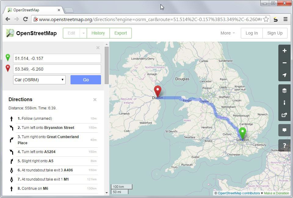
OpenStreetMap just announced that it has added a directions feature to its main website. While services such as OSRM or Mapquest that use the data provided by OpenStreetMap have been offering direction features for some time, this was not the case for the main project website until today.
One of the reasons why the makers of OpenStreetMap decided to integrate directions on the main website is that the lack of the feature may have given some visitors a false impression.
Since directions were not provided on the main site they assumed that the mapping service did not support it.
The feature works similar to the directions feature on sites like Google Maps or Bing Maps. Add a start location and destination and wait for the results to be populated.
Car is selected as the default means of transportation which you can change to bicycle or foot. Two data sets are available for each transportation type so that you can switch between them to find the better result.
As you can see on the screenshot above, some roads are not named yet and appear as unknown. This depends largely on the available data but since it is an open project, users can hit the edit button to add missing information.
This is actually another reason why directions has been added as it is a lot easier to spot places or roads that have not been named at all or named improperly. Note that you need an account to edit information on the map.
Missing information are still unfortunate for you if you just want to get directions and don't have the time to edit them manually. The way is displayed on the other hand but orientation may be difficult depending on how many "unnamed" entries are displayed to you.
Still, it is very likely that this will get better over time once users of the service start adding information to it that are missing.
To be fair, services like Google Maps do provide additional information such as public transit or flights that OpenStreetMap does not at this point in time. If you require those you won't be able to use the service for now.
Still, the integration makes sense on many levels.
Now You: Which service do you use to look up directions?


I don’t drive… public transport, walking, biking is my mode of transportation for local destinations with the options for bus, train and plane for ones further off. As for what map I use. I like the street level view from Google Maps, but sadly they are quite a few years behind for my city. A city which is the largest in Canada by population and size and we are next door neighbors to the USA but that hasn’t sparked any interests in updating our street views.
So though their concept is a good one, it used poor algorithms at the time to make the images which are poorly stitched together. The info blocker to smear license plates on vehicles caught in the frame does a decent job, but it isn’t limited to license plates, it also smears street addresses which are not private otherwise people would not put numbers on the exteriors of their homes.
Zooming out in overhead mode, they say the image is displayed is approximately xx or xxx feet or meters above ground, but the distorted and fuzzy image is just a ridiculously enlarged satellite image. Unlike USA major cities, when we zoom in we can see the tops of people’s head and can make out other landmarks easily. Oddly enough Vancouver, Canada’s 3rd largest city (Quebec City is the 2nd) has street level maps where I can make out cars and even street corner newspaper and mail boxes.
In Toronto, if we scroll down below the mile or kilometer mark (depends on how you setup your account views) we can’t tell the tops of houses from the tops of trucks. Cars look like a smudge. So Canada’s largest city gets crappy maps, while Vancouver gets decent ones. So for overhead views I use Bing Maps because their overview data was done by planes/drones, while Google Maps rely too much on Satellite imagery.
I find that I still rely on Garmin GPS. The desktop maps are useless on the road. The Android Maps directions are wrong about 2% of the time. And if you travel faster than 80mph, the map doesn’t update fast enough for directions. And the phone overheats on top of that.
Have you tried Wayz?