qMetro: subway maps and travel information application
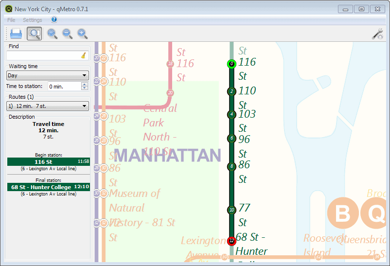
One of the first things that I do when I visit a foreign country or city I do not know about, is to grab a subway plan as I usually use it for my travels.
Sometimes, apps are available that provide me with the information, at other times, paper maps are available in hotels or stations that I can make use of.
The open source software qMetro offers another option. It is a cross-platform application that ships with a large selection of subway maps included, and options to download additional maps from the Internet.
The default maps include popular cities such as Amsterdam, Berlin, New York, Moscow, Paris, London or Delhi. The maps available on the website add many more cities to the list.
Vectors are used for the maps, and you can zoom in and out using the mouse wheel or the buttons in the main toolbar.
To calculate the travel time, click on a station name and then on the name of the destination. The program displays the information to you the.
Here you can make slight modifications, including the time it takes you to reach the station, the waiting time, and if available, different routes.
What you cannot seem to do, and that is without doubt an issue, is to change the time you want to take the subway. While the information presented to you are helpful, you do not really know if they are also accurate for the day and time you want to take the subway to the destination.
You can make a couple of modifications in the program's settings. Here you can change the default font type and size for example, which you may want to do as the default font is not that readable.
Other options include adding or removing shadows, colors or transparency effects on the map. If you notice performance issues, you may want to check the performance settings to make modifications here. You can for instance enable simple graphics for transfers, or enable caching.
To load a different map, select File > Open from the options. New maps can be downloaded from this website. Just place the downloaded maps in the same folder the other maps reside in. You can load them from there using the application then once that is done.
Verdict
The qMetro app has several things going for it. It is cross-platform and open source, supports more than one hundred Metro maps, and can be used offline.
The travel information are less useful than they appear to be on the other hand, and if you do have an online connection, you are probably better off using Google Maps or Bing Maps for that instead.
Advertisement











hi,
Thanks for your article. You should mention Metro (http://nanika.net/index-en.html) that is, in my opinion, the best app for PDA and Smartphone (only) to find any direction in Metro, Tube and others Underground transportation. Itr’s free, without any ad, offline, and available on many platforms.
All the best.
Metro is okay as a general guide, but for pinpoint accuracy, the Android apps created by: George Schneeloch (https://play.google.com/store/search?q=George%20Schneeloch&c=apps&hl=en) rely on the GPS transponders of the individual buses to track route, GPS of the mobile phone user, destination, travel and arrival times. As of current he only has data for five city bus systems and I am lucky my city is one of them.
We can search for individual bus numbers, or the bus stop by route, or if your device has enough processing power, you can select, “Show All buses”, or “Show All Routes”. The map updates as frequent as once every 15 seconds and you can even see the direction the bus is traveling to/from the station/stop. We can even use the app as a GPS locator when we use the, “Find Me”, function which relies on the accuracy of your service provider which can be supplemented by turning on WiFi with Data to further pinpoint your location on the Google Map.
The developer has told me he and his team will accept requests to add any city so long as its bus system uses GPS transponders. So far the only cites he has added is, Boston, Los Angeles, NY City + Manhattan, Toronto and University of Michigan bus system. There is no ads I am aware of, at least for my city (Toronto).