Google is adding crosswalks and other details to Google Maps
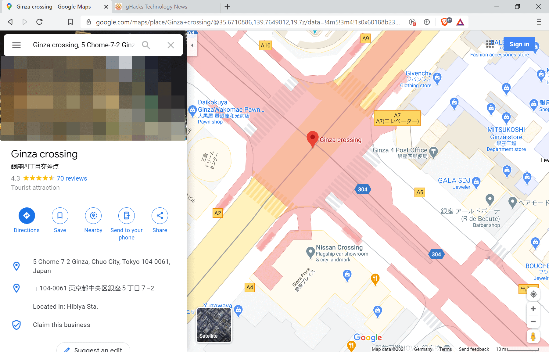
Google started to roll out an improved version of Google Maps in January 2021. The new version introduced details, such as crosswalks, footpaths, pedestrian refuge islands, to Google Maps. The functionality is still rolling out and only available in select locations at the time of writing.
Probably the most interesting part of the change is that Google is using an automated system for much of the data. Google is analyzing and processing satellite imagery and Street View recordings automatically to introduce the new level of details on Google Maps.
The first cities that received the treatment are London, New York, San Francisco, and Tokyo. The rollout and the limited number of locations with the feature suggests that it is used for testing purposes. Google needs to make sure that the error level is low before rolling out the functionality to other locations in the world.
The following screenshot demonstrates how crosswalks are now displayed on Google Maps in those locations.

The new level of detail adds more information to Google Maps. Besides the already mentioned crosswalks, footpaths and pedestrian refuge islands, users may see additional details such as transportation facilities and even edge of carriageway details.
Some details may need adjusting. If you zoom in on Central Park in New York, you may notice that it is harder to follow footpaths on the new updated Google Maps. Footpaths, displayed as a solid line previously may lack path information on the new Google Maps.
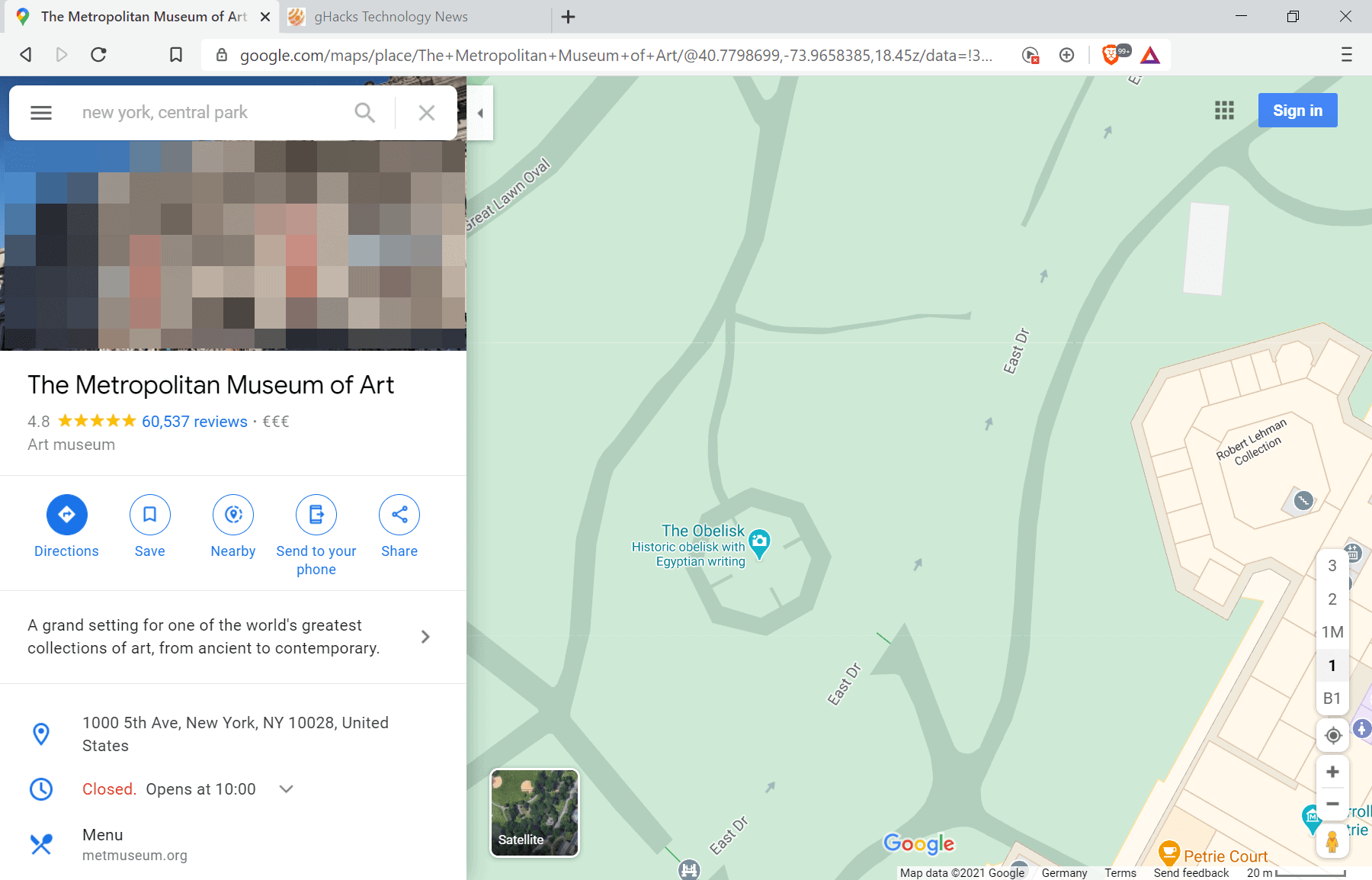
It is unclear at this point whether Google will fine tune the display of footpaths before rolling out the new level of detail to additional regions.
Closing Words
Details such as crosswalks or pedestrian refuge islands are useful additions to Google Maps as they are useful to pedestrians. The improved level of details needs a bit of adjusting and tinkering, especially when it comes to the display of footpaths.
Now You: Which map service do you use, and why?









Which map service do you use, and why?
None, because my personal assistants deal with all that map crap.
Wow, that pedestrian footpath is *REALLY* hard to make out! Otherwise, crosswalks seem like a useful addition. And I suppose pedestrian refuge islands, too — at least in France, the only place I’ve had drivers honk and flash their lights at me because I was crossing a crosswalk. Being able to choose a crosswalk with a refuge island in the middle could improve your odds of survival. Maybe in the future, Google could provide an estimate of how much time it takes to run between the sidewalk and the island, depending on your age and physical condition… ;-)
When Google Maps will start showing public transport traffic in real time?
Yandex Maps does an excellent job with this in Moscow!
Competition and all that! :)
Check with your public transit, they may offer that already. My little city has transponders on every vehicle which displays their location on the transit system website. I’ll take that over Google Maps anyday.
The problem is most likely in Google, before this function was.
But then Google decided to remove it for some reason …
We should try to contact Google, find out why it was removed, and whether it will be returned …
Crosswalks, what we call crossings or pedestrian crossings?
@Martin Watson: yes, Martin B is using AmeriSpeak.
Tongue, cheek…
I drive in a parkway, park in a driveway, and get high on the freeway.
For path walking and getting accurate maps of localities – Openstreetmap.
For walking in hills – Google Earth.
For seeking out the access to a business – google maps+street view.
Generally Google maps misses a lot and has a very large number of errors, probably caused by automated mapping.
That openstreetmap is great for urban trails, thanks for the find!
I don’t know where in the world you live, Ray, but here (UK) Google Maps is head and shoulders above the alternatives.
Open Street Maps has way less data available than Google Maps and while the latter makes it easy for the user to add stuff like locations, roads, images; OSM makes it almost like a chore. The amount of effort required to input the same data amongst the two platforms is significantly different.
Another step towards implementation of the Big Brother surveillance system.
i will sue google because of forcing me to solve some fu…ng endless captcha, I think I’m slave in their business model.