Compare public transport options with allryder
Unlike in the US, where public transport is not really that great in most regions, public transport in Europe is often a great option to get from point a to b, especially in major cities and regions.
You often have the choice between several options, from trams and buses to trains and public bikes.
Allryder is a free application for Android and iOS that provides you with information about all those different options. It is currently supporting several major European cities such as Berlin, Hamburg, Munich, Vienna or Dublin completely while others are supported partially or not at all currently.
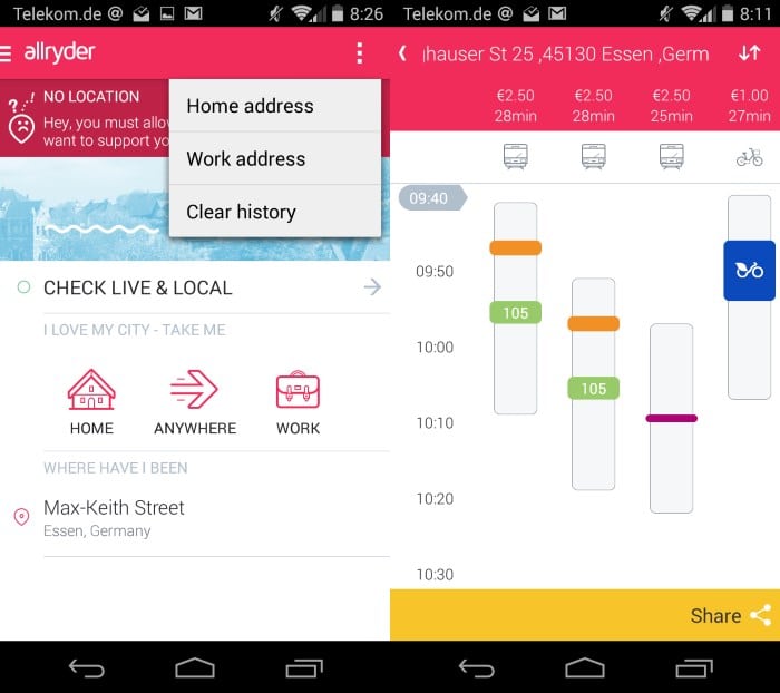
The first thing that you may want to do is add a home address which can be used for searches. You can add a work address as well which is quite good as you can look up live public transport information then with just a tap whenever you require information.
Besides checking the home to work or work to home route, you can also check other routes which are added to the "where i have been" listing of the app so that you can access them again in the future with just a tap as well.
When you check a route all available transport options are displayed to you on the screen. This may include tram and bus routes, bike or car sharing information options or cab depending on where you are and where you want to go.
Each option is listed with price and travel information so that you can pick the right one easily from the list. Please note that allryder displays only public transport at the time of writing and not other options such as walking to the destination or driving in your own car.
A tap on a suggested option displays detailed information about it. It lists how to get from your start location to the destination using the selected transport. This may include other transport options as well such as walking to a station.
Closing Words
Allryder is a nice application with potential. I like how it saves locations for you so that you can look up travel information with just a couple of taps without having to enter anything.
It is fairly limited right now in terms of cities it supports which is unfortunate. If you are living in one of the supported cities or spending time there then it can definitely be useful to you.
I'd also like to see customization options added to the travel options page. First, I'd like to disable checks for options that I'm never going to use. Second, I'd like to see foot and car routes added to the app for comparison purposes.












Dear Martin,
Thank you so much for your kind review. We really enjoyed reading your piece and your constructive feedback. Please be assured that we are working on our expansion and also on making the app more tailored to personal needs.
In case you have any other input or idea what you would like to see, we’d love to hear it.
Kind Regards,
Nadine from allryder
Of course, Martin! In Germany where I worked with your great grandparents to build that sort of transportation. You should thank me and praise the impact that I have done to Germany. Goot goot, where is my sausage now..
Each city has it’s own form of public transportation services and out there somewhere someone is writing or has written an APP for us. In my city of Toronto our major public transport system is called, TTC (Toronto Transit Commission) and though the TTC has an APP in both Android and iStore, their APP is seriously lacking and only works half of the time. In steps 3rd party APP writers. For my city of Toronto (Canada), there is an APP known as, “TorontoBusMap”. The author has one for Boston, Los Angeles and University of Michigan (BostonBusMap, LosAngelesBus & UMich BusMap). He plans on adding more in the future but has no immediate plans at the moment.
https://play.google.com/store/apps/details?id=com.schneeloch.torontotransit&hl=en
His APP, works by using / tracking buses with GPS transponders to determine estimated times of arrivals as well as showing live updates where a bus is on the map and how far away from your location it is currently as well as the direction it is travelling in. The amount of information and the accuracy is so astonishing even TTC bus operators rely on it citing it’s accuracy and bountiful information for every route and sub route bus.
That to me is what a bus APP should have and the funny thing is the author (George Schneeloch) does not have a request for donations, or fee nor does he require any, no spam, no ads.. He claims he does this as a hobby. Good for him.
Here’s to hoping the developer branches out! :)
I think that should be their number one priority. After that, I’d add more features to the program.